A prioritization tool to rehabilitate bird colony islands along the Texas Coast
About the CINDI Project
Every four years the Texas General Land Office (GLO) produces an updated Texas Coastal Resiliency Master Plan (CRMP) that includes a list of high priority (“Tier 1”) colonial waterbird nesting islands in need of rehabilitation. The basis for including an island in the Tier 1 list and for selecting which Tier 1 projects to implement, is based on expert opinion with little understanding of how an individual rehabilitated island contributes to the regional population of birds. With 300 colony islands on the Texas coast, agencies do not have enough funds to intensively manage all of them. Nor do all islands have the same potential to increase regional waterbird populations. Therefore, a data-driven prioritization tool that incorporates bio-geo-physical constraints on nesting, as well as social, cultural, and economic considerations, is needed by third-party colony island advocates to prioritize colony island projects for inclusion in the Tier 1 category of the CRMP and for movement from the Tier-1 list to implementation.
The project extends the spatial coverage of a two-year pilot study by the Harte Research Institute (HRI) and partners from a small section of GLO CRMP Region 3, southward to the Rio Grande River and northward to the east side of Galveston Bay, which encompasses the great majority of waterbird colony islands on the Texas coast. The goal of CINDI is to co-produce and implement a prioritization tool that helps managers prioritize a network of colony islands where rehabilitation and management are cost effective and the potential for enhancing waterbird populations is high. To achieve this, natural resource managers must better understand how colony island traits, foraging habitat, and landscape characteristics influence waterbird breeding productivity. The association between colony traits and colony nesting success will be determined by measuring the number of chicks produced across a range of colony types for 5 focal bird species (Black Skimmer, Caspian Tern, Tricolored Heron, Reddish Egret, and Great Egret) using drones. Movement data from radio-tagged birds will be used to map foraging ranges and develop a model to estimate the probability of habitat. Existing monitoring data on small fish from the Texas Parks and Wildlife Department will be used as a measure of prey availability within species-specific foraging ranges. The prioritization tool will use a statistical programming algorithm to identify a set of colonies that maximizes colony persistence, nest survival, and access to foraging habitat with a high probability of use, while minimizing project costs.


Components of CINDI

Co-production
This project uses a co-production process to set conservation targets that define the conservation planning problem solved by the prioritization tool. The co-production process leverages knowledge across participants through engagement to promote more effective science products and helps ensure that the maps have a high probability of being adopted by the natural resource managers who were involved in their development. Production is split among four teams which handle various components of the project. Learn more in the Team section.

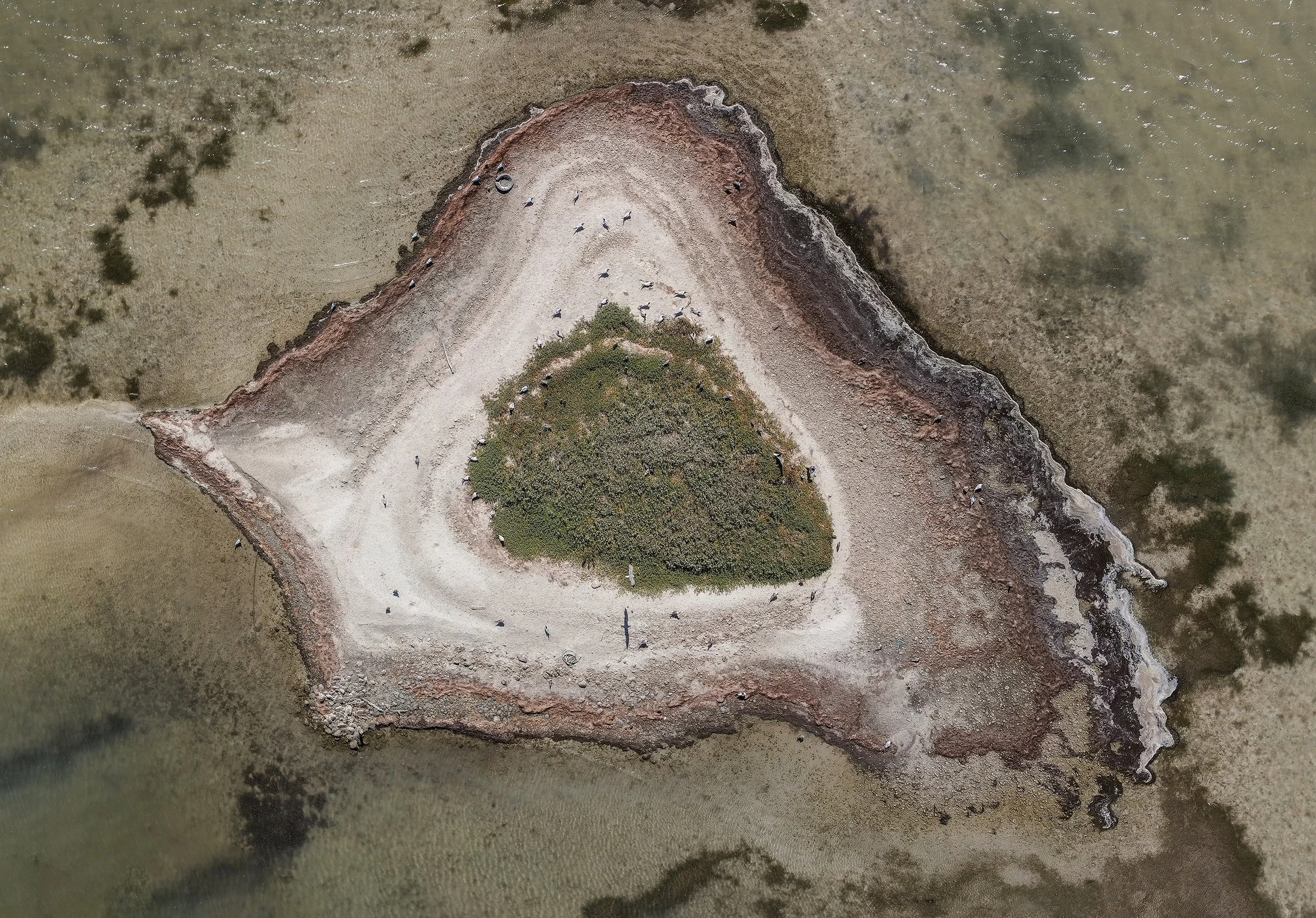
Colony Productivity
The colony productivity portion of the CINDI project utilizes information taken from weekly drone surveys conducted during the breeding season on 20 islands across the Texas coast. Photos are taken with a high-resolution camera and all files are georeferenced to produce orthomosaics used to track individual nest progress. Productivity metrics including daily nest survival and mean brood size will be modeled with various island characteristics to identify island traits most associated with bird productivity of the 5 focal species. Inclusion of these data will boost both the sample of islands where productivity is measured and the power of the analysis to test for differences in reproductive performance among island types.
Waterbird Telemetry
Solar GPS-GSM tracking devices are fitted on each of the 5 focal species by Texas A&M University Kingsville and Coastal Bend Bays & Estuaries personnel from various colony islands across the Texas coast. Telemetry data will provide valuable information on where birds are foraging and will offer deeper insight on microhabitat selection that will be used in the island prioritization tool to predict probability of habitat availability at each colony island. These data will produce a bioenergetic-based model that incorporates telemetry data to establish the carrying capacity of each focal species based on the available energy in the foraging habitat. The bioenergetic model will be based on habitat-specific prey biomass from annual bag seine samples dating back to 1976 collected by the Texas Parks and Wildlife Department. Mean biomass per prey type will be converted to available energy using published mathematical functions for groups of fish with similar body sizes.

Social Considerations
The systems that bird colonies exist in are used by more than just birds. The CINDI Project will incorporate social, cultural, and economic considerations to maximize the utility of the islands for birds while balancing economic feasibility and social factors as well.

Modeling
The modeling component produces a GIS-based prioritization model that combines variables affecting colony persistence and size based on an analysis of Texas Colonial Waterbird Survey data collected annually on the Texas coast since 1973, with biological, physical, economic, and social variables identified by stakeholders and waterbird experts in a series of workshops. Economic variables will include monetary metrics for sediment transportation and placement as well as metrics related to ecosystem services associated with different island types, such as carbon sequestration, shoreline erosion reduction, and aesthetics. Social variables will include proximity to residences, recreational areas, or other cultural icons. The biotic and physical variables identified through expert knowledge in the workshops will be used to inform the analysis of Texas Colonial Waterbird Survey data. The GIS-based prioritization model will combine data from expert knowledge and the empirical analyses to rank islands for rehabilitation based on predicted gains in bird numbers and productivity. The final model, completed in year 4, will include socio-economic factors and parameters from the two field components. The effects of sea level rise will be incorporated through predicted changes in the areal extent of foraging habitat and colony island surface as simulated sea surfaces fluctuate.